
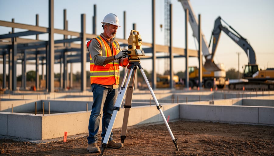
Construction site surveyors transform architectural plans into physical reality by establishing precise measurements and reference points that guide every phase of building. These professionals use specialized equipment—from traditional theodolites to modern laser levels and total stations—to mark boundaries, set elevations, and ensure structures align exactly with design specifications. Without accurate surveying, foundations shift, walls lean, and costly errors multiply.
Understanding when you need a surveyor versus when DIY measuring suffices can save thousands in rework. For simple projects like garden sheds or decking, basic leveling tools and measuring tapes often work fine. Complex builds requiring foundation work, property boundary verification, or multi-story construction demand professional surveying to prevent legal disputes and structural failures. Many construction projects legally require certified surveys before work begins, particularly for new builds or significant renovations.
Site surveyors do more than measure—they create detailed site maps, identify potential drainage issues, calculate cut-and-fill volumes for earthworks, and provide ongoing layout verification throughout construction. They bridge the gap between design teams and construction crews, translating two-dimensional drawings into three-dimensional ground markings using stakes, paint, and laser technology.
Whether you’re a tradesperson expanding your skills or a homeowner managing a build, recognizing the surveyor’s role helps you communicate project requirements effectively, anticipate workflow dependencies, and decide whether hiring professional surveying services or renting precision measuring equipment suits your specific project scope and budget constraints.
What Does a Construction Site Surveyor Actually Do?
The Difference Between Land Surveyors and Construction Site Surveyors
While the terms sound similar, land surveyors and construction site surveyors perform distinct roles that serve different phases of a project. Understanding this difference helps you hire the right professional for your needs.
Land surveyors focus on establishing legal property boundaries, creating topographic maps, and producing official documents for property transactions or development approvals. They’re typically licensed professionals who verify where your property begins and ends, identify easements, and prepare subdivision plans. You’ll need a land surveyor when purchasing property, resolving boundary disputes, or obtaining planning permits.
Construction site surveyors, on the other hand, work during the building phase itself. They translate architectural plans into physical reality on-site, ensuring foundations, walls, and infrastructure go exactly where they should according to the design. Their work is about precision placement rather than legal boundaries.
Think of it this way: a land surveyor tells you what you own and where you can build, while a construction site surveyor ensures what you’re building goes in the right spot. Many larger projects require both professionals at different stages. For smaller residential projects, homeowners might only need a land surveyor initially, while builders handle basic layout themselves using rented surveying equipment for straightforward measurements.
Essential Surveying Tasks That Make or Break Your Project
Initial Site Layout: Setting the Foundation Right
Before any excavation begins or foundations are poured, surveyors establish the critical framework that guides the entire construction project. This initial layout phase involves three key activities that determine whether your project stays on track or faces costly corrections down the line.
First, surveyors establish control points—permanent reference markers placed strategically around the site. Think of these as your project’s GPS coordinates. They create fixed points that builders return to throughout construction for verification. If these shift or are inaccurately placed, every subsequent measurement compounds the error.
Next comes marking property boundaries. This isn’t just about avoiding disputes with neighbours—it ensures compliance with setback requirements (the minimum distance between your structure and property lines). Getting this wrong can mean demolishing work that encroaches into restricted zones, an expensive mistake that some builders have faced after skipping professional surveying.
Finally, surveyors take baseline measurements for foundation positioning. These include elevation readings and horizontal positioning that determine where footings, slabs, and load-bearing elements will sit. A few centimetres off at this stage can create drainage problems, structural issues, or misaligned walls.
The investment in accurate initial surveying typically represents less than 1% of total construction costs, yet prevents errors that can cost 10-50 times more to rectify. According to community feedback from professional builders, projects that skip this step face an average 15% increase in unexpected correction costs.
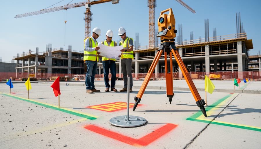
Setting Out: Translating Plans into Physical Reality
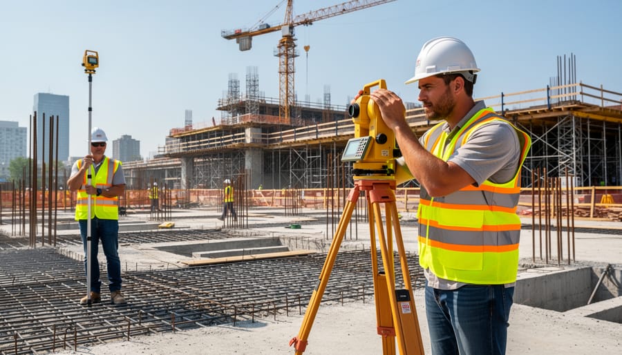
Once the surveyor has analyzed the site and established control points, the next crucial step is setting out—the process of transferring architectural plans from paper into precise physical markers on the ground. This is where construction truly begins to take shape.
Setting out involves marking the exact positions where foundations will be dug, walls will rise, and columns will stand. The surveyor uses the control points as references to measure and mark these locations with millimeter accuracy. Even small errors at this stage can cascade into costly problems later, so precision is everything.
Modern surveyors rely on several key tools for this work. Total stations—electronic instruments that measure angles and distances—are the industry standard for accurate positioning. These devices can calculate coordinates and guide the surveyor to exact points. For larger sites, GPS equipment provides positioning data, though it’s less accurate than total stations for detailed work. Laser levels project visible reference lines for establishing elevations and ensuring everything sits at the correct height.
The physical marking process uses wooden stakes, spray paint, or metal pins to identify key positions. On concrete surfaces, surveyors might use chalk lines or marker paint. For vertical elements like columns, they’ll mark center points and reference lines that builders can follow.
Professional tradespeople typically hire qualified surveyors for this stage, as the specialized equipment requires training to operate effectively. However, understanding the process helps everyone on site appreciate why these marked positions must be followed precisely during construction.
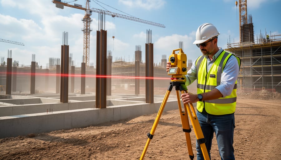
Level Monitoring and Elevation Control
Surveyors play a critical role in maintaining correct elevations throughout construction, preventing costly mistakes before they become permanent. Using instruments like laser levels, total stations, and GPS equipment, they establish precise benchmarks that guide everything from site preparation to finished floor levels.
One of their primary responsibilities involves ensuring proper grading and drainage across the site. This means checking that land slopes away from structures at the correct angle, typically around 2% minimum, to prevent water pooling near foundations. They also verify that floor levels match architectural plans, which is essential for installing fixtures, doorways, and ensuring accessibility compliance.
Accurate leveling prevents several common construction problems. Without proper elevation control, you might encounter water infiltration into buildings, uneven concrete slabs that require expensive grinding or resurfacing, drainage systems that don’t flow correctly, and misaligned structural components that create fitting issues later. For multi-story buildings, even minor elevation errors compound at each level, potentially making upper floors unusable.
Professional surveyors typically check elevations at multiple construction stages, from initial earthworks through final finishing, ensuring each phase meets specifications before work continues.
As-Built Surveys: Documenting What Actually Got Built
An as-built survey creates a permanent record of what actually ended up in the ground and behind the walls, compared to what the original plans showed. Think of it as a snapshot taken after construction wraps up. Real-world building rarely follows plans perfectly. Pipes might shift half a meter to avoid unexpected rock, foundations may sit slightly different due to soil conditions, or electrical conduits could route around obstacles discovered during excavation.
This as-built documentation becomes invaluable years later when someone needs to dig near your property, add an extension, or locate underground services. Without accurate as-built records, future contractors essentially work blind, risking expensive damage to hidden utilities. These surveys also provide legal protection if boundary disputes arise or if you need to prove compliance with approved plans. For commercial projects, as-built surveys are typically mandatory, while residential projects benefit greatly from having them, particularly for complex installations like septic systems or extensive landscaping that altered drainage patterns.
The Surveyor’s Toolkit: Equipment You’ll See on Site
Total Stations and Theodolites
Total stations and theodolites represent the high-precision end of surveying equipment, combining angle measurement with electronic distance measuring capabilities. A total station is essentially a digital theodolite integrated with a laser distance meter and onboard computer, allowing surveyors to capture both horizontal and vertical angles along with distances to calculate exact positions in three-dimensional space.
These instruments are essential for large-scale construction projects requiring millimeter-level accuracy, such as high-rise buildings, bridges, road construction, and complex site layouts. They excel at establishing precise control points, setting out building corners, checking vertical alignment of structural elements, and creating detailed topographic surveys.
For most residential projects and simple site work, total stations are optional. A basic builder’s level or laser level typically suffices for foundation work and grading. However, when your project involves complex angles, multiple elevation changes, or strict regulatory compliance for site boundaries, hiring a professional surveyor with a total station becomes necessary.
Rental costs for total stations range significantly based on features and accuracy levels. While they’re user-friendly compared to older theodolites, proper training is crucial. Many hire centers offer brief tutorials, but without surveying knowledge, you risk costly errors. For most DIY projects, it’s more practical to hire a qualified surveyor for critical measurements rather than renting this specialized equipment yourself.
GPS and GNSS Systems for Site Surveying
GPS (Global Positioning System) and GNSS (Global Navigation Satellite System) technology has revolutionized construction site surveying by providing accurate positioning data through satellite signals. These systems allow surveyors to determine precise coordinates anywhere on a site within minutes, rather than the hours traditional methods might require.
Modern GPS/GNSS receivers can achieve accuracy ranging from several meters down to millimeter-level precision when using advanced techniques like Real-Time Kinematic (RTK) positioning. This technology is particularly valuable for large-scale projects where establishing control points quickly saves substantial time and labor costs.
The main advantages include speed, consistency across vast areas, and the ability to work with just one or two operators rather than requiring a full survey crew. These systems excel in open areas where satellite signals remain unobstructed.
However, GPS/GNSS does have limitations. Dense urban environments with tall buildings, thick tree canopy, or working indoors can block or weaken satellite signals, reducing accuracy or making measurements impossible. Weather conditions like heavy storms may also interfere with signal quality.
For DIY projects or smaller construction jobs, understanding these limitations helps determine whether renting GPS equipment makes sense or if traditional surveying tools might prove more practical for your specific site conditions.
Laser Levels and Rotating Lasers
Laser levels and rotating lasers are essential tools that project precise horizontal or vertical reference lines across work areas, making them invaluable for construction site surveyors and practical for various DIY projects. These tools use laser technology to establish perfectly level lines over long distances, eliminating the traditional need for manual measuring and leveling.
Professional surveyors rely on rotating lasers for large-scale site work, including establishing foundation heights, checking ground slopes, and verifying elevation points across expansive areas. The rotating beam creates a 360-degree reference plane that multiple team members can use simultaneously. Standard laser levels work similarly but are better suited for interior projects like installing cabinets, tiling walls, or hanging shelving at consistent heights.
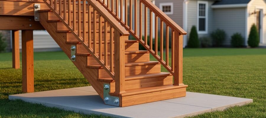
For DIYers, these tools simplify projects that once required professional expertise. Weekend warriors commonly rent them for deck building, fence installation, and basement finishing work where level reference points are crucial. The technology automatically compensates for minor surface irregularities, providing accuracy within millimeters.
When renting, consider your project scale. Compact line lasers suit indoor renovations, while outdoor grading or excavation projects benefit from self-leveling rotating lasers with receivers. Most rental centers provide basic instruction, and user reviews often highlight which models are most intuitive for beginners versus experienced tradespeople.
When Your Project Needs a Professional Surveyor
Understanding when to call in a professional surveyor versus tackling measurements yourself can save you time, money, and potential legal headaches. Here’s a practical breakdown to help you make the right choice.
You absolutely need a professional surveyor for any project involving property boundaries or legal documentation. This includes installing fences along property lines, subdividing land, resolving boundary disputes with neighbors, or obtaining building permits for major construction. Land registry offices and local authorities typically require certified survey documents, and DIY measurements won’t meet these legal standards. Similarly, large-scale commercial projects, site grading that affects drainage patterns, or any work requiring elevation certificates demand professional expertise.
For smaller residential projects like building a garden shed away from boundaries, laying a patio, or installing landscaping features, DIY measuring with quality equipment often suffices. Setting fence posts well within your property line or planning interior renovations are also suitable for self-measurement. The key question is whether your project has legal implications or requires official documentation.
From a cost-benefit perspective, professional surveys typically range from several hundred to several thousand dollars depending on property size and complexity. While this might seem steep, it’s minor compared to the cost of rebuilding structures placed incorrectly or legal fees from boundary disputes. Consider that moving a misplaced fence or garage can cost tens of thousands.
Many tool hire centers offer surveying equipment like laser levels, measuring wheels, and basic theodolites for DIY projects. These work brilliantly for projects without legal requirements. However, remember that operating precision instruments requires practice and understanding. If you’re uncertain about your project’s scope or local regulations, consult your local planning office before proceeding. They’ll clarify whether you need certified documentation or if DIY measurements meet your needs.
Common Surveying Mistakes That Cost Time and Money
Even experienced professionals make surveying mistakes that can derail projects and budgets. Understanding these common errors helps you avoid costly setbacks.
One frequent mistake is failing to establish proper control points before starting. A community member shared how skipping this step on a home extension project resulted in foundation misalignment, costing £3,200 to correct. Always verify your reference points match official site plans before taking measurements.
Inadequate equipment checks cause surprising problems. Several users reported discovering their laser levels had calibration drift mid-project, leading to walls that were off by several centimeters. Make it standard practice to verify equipment accuracy daily, especially when working across multiple days.
Weather conditions often get overlooked. Heavy rain, extreme heat, or strong winds affect instrument readings more than most people realize. One tradesperson recounted how moisture on prism reflectors during drizzle caused consistent 15mm errors throughout an entire site layout. When conditions aren’t ideal, either postpone surveying work or take extra verification measurements.
Poor documentation creates serious headaches later. Multiple DIYers mentioned losing crucial benchmark data because they relied on memory rather than detailed notes and photographs. Digital documentation with timestamps and GPS coordinates prevents these issues.
Communication breakdowns between surveyors and construction teams frequently cause rework. Always conduct stake-out verification walks with the entire team before excavation begins. One contractor estimates this simple step has saved his company over £20,000 in prevented errors over five years.
Working Safely Around Surveying Activities
When working on a construction site where surveying is taking place, respecting the surveyor’s workspace protects both the accuracy of measurements and everyone’s safety.
First and foremost, never move, touch, or disturb survey markers like stakes, pins, or tripods. These reference points are critical for the entire project’s layout, and even small shifts can cause costly errors. If you’re unsure whether something is a survey marker, ask before proceeding with your work.
Maintain awareness of sight lines between surveying instruments. These are the invisible pathways between a surveyor’s equipment and their target points. Walking through an active sight line interrupts measurements and can delay work. If you see a surveyor looking through equipment or holding a prism rod, wait for them to signal before crossing their work area.
When handling surveying equipment yourself, whether rented or borrowed, always use protective cases during transport. Laser levels and total stations contain sensitive components that misalign easily with rough handling. Set up equipment on stable, level surfaces away from heavy machinery vibrations.
Communicate with the surveying team about your planned activities. Excavation, material deliveries, and equipment movement can all impact survey accuracy. A quick conversation prevents conflicts and keeps the project moving smoothly. Remember, surveying establishes the foundation for everything that follows, making cooperation essential for successful construction outcomes.
A construction site surveyor brings far more value than simply taking measurements—they’re your first line of defense against costly mistakes that could derail your entire project. Whether it’s preventing foundation misalignment, catching grade issues before concrete gets poured, or ensuring your addition doesn’t accidentally encroach on property lines, these professionals save you from problems that are exponentially more expensive to fix after the fact.
If you’re tackling a major construction project, hiring a qualified surveyor is worthwhile. Check their credentials, ask about their experience with projects similar to yours, and don’t hesitate to read community reviews from other builders and homeowners. Professional organizations and local licensing boards can verify qualifications and help you find reputable surveyors in your area.
For simpler tasks like basic layout work or establishing level grades for patios and landscaping, you might consider renting surveying equipment yourself. Modern laser levels, rotary lasers, and GPS units have become increasingly user-friendly. Browse community-driven reviews from other DIYers and tradespeople to find equipment that matches your skill level and project requirements. Many tool rental centers offer brief tutorials to get you started, and online forums provide valuable tips from people who’ve tackled similar projects. Whatever route you choose, investing in accurate surveying upfront always pays dividends.
Related Posts
Post a Comment